Once the weather was predicted by the shape of the clouds. Now we have supercomputers, but they are not always accurate. Understanding how the weather is predicted in the 21st century
A weather forecast is a scientifically based guess about what the weather will be like at a certain time in a certain place. The science of weather and methods of predicting it is called synoptic meteorology. It is part of meteorology – the science that studies the Earth’s atmosphere and the phenomena occurring in it. The people who make forecasts are called forecasters.
Weather forecasts can be roughly divided into:
- by terms (ultra-short-term, short-term, medium-term and others);
- by territory coverage: local, regional, country, world (global);
- by appointment: general use, aviation, sea, river and agricultural.
The weather forecast can be made using:
- analysis of a synoptic weather map – a geographical map on which the results of observations of meteorological stations at certain points in time are shown in the form of numbers and symbols;
- numerical methods of weather forecasting – a computer mathematical model of the atmosphere, which is built on the basis of a system of hydrodynamic equations and current weather data;
- statistical methods – the collection of statistical weather data, based on the assumption that the weather will repeat itself in the future.
This method complements the numerical one.
Today, almost all countries have regional national weather services. Hydrometeorological Center for Russia, Meteofrance for France, Offenbach for Germany, etc. Meteorological data on the current state of the atmosphere are collected there for further calculations of weather forecasts. All national meteorological services exchange information with the World Meteorological Organization (WMO), whose members are 193 states and 6 territories.
Where do forecasters get their data from?
To predict the weather, you need to know the “current conditions” – that is, what it is now. The main parameters include: temperature, atmospheric pressure, humidity, wind speed and direction, precipitation and their amount.
Modern weather forecasting is based primarily on satellite data, and weather stations, probes and radars correct and continuously supplement them. Together, all these sources create a complete picture of what is happening in the atmosphere.
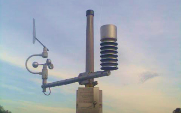
Weather stations are special sites where meteorological measurements of weather and climate are continuously carried out. The stations are equipped with instruments for meteorological measurements: thermometer, hygrometer, barometer, precipitation gauge and other devices. They are the same all over the world. For accuracy, meteorologists take measurements regularly and synchronously – every 3 hours.
Ground weather stations are different: huge masts in the fields, floating buoys in the sea, ball-shaped radars. Some of the stations are located in the form of autonomous devices in hard-to-reach places, such as mountains and seas.
Weather stations have disadvantages: they collect data only near themselves, are located far from each other and do not know the amount of precipitation.
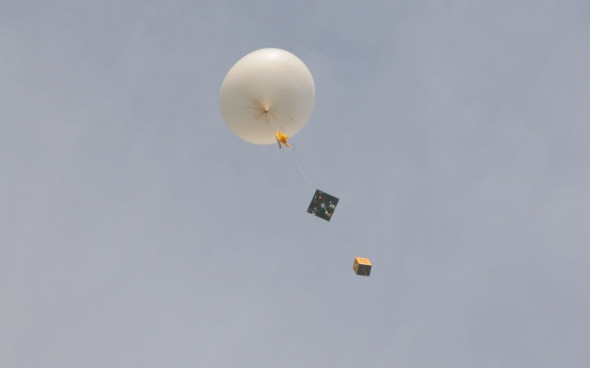
Weather balloons
Weather balloons are unmanned balloons. The probe looks like a rubber or plastic balloon filled with helium, to which a container with equipment is attached – sensors for measuring temperature, humidity and atmospheric pressure, as well as batteries and an antenna with which these data are transmitted.
One weather balloon weighs about 300 grams and rises to a height of 30–40 kilometers. Probes are disposable: gaining height, the balloon bursts from excess pressure. The styrofoam container falls to the ground and is not reused.
Weather balloons are launched at 870 points of the Earth twice a day, usually at 00 and 12 hours UTC.