The main types of forecasts and their features.
In a recent post, we talked about how weather forecasts are made, what forecast models are, and how they work. Today we will consider in more detail the main types of forecasts and their features.
Weather forecasts are usually classified according to the degree of lead time into three main groups: short-term, long-term and nowcasting (forecasts “for now”). Among them, there are also medium-term (advisory, from 4 to 10 days) and climate forecasts (for a period of more than 2 years).
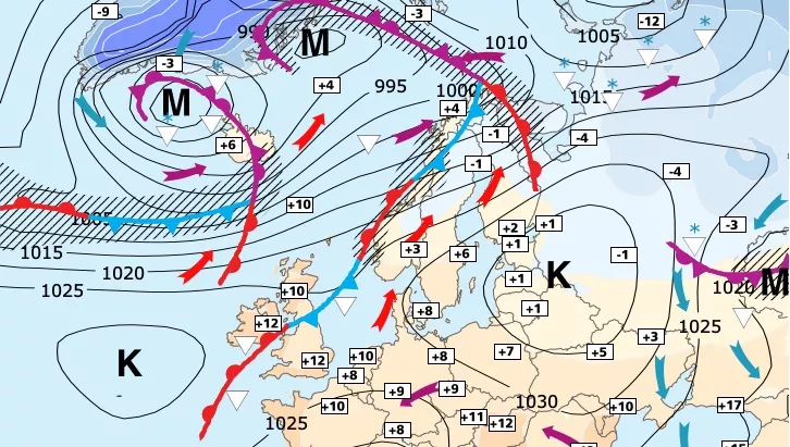
Compilation of short-term weather forecasts is the task of forecasters of national meteorological centers or their subdivisions. These are the most demanded and popular forecasts, which are prepared for the next 1-3 days. The methodology for compiling them is such that, first, the forecaster identifies large-scale processes in the atmosphere that determine the nature of the weather in general terms. For this purpose, a synoptic analysis is usually carried out. Its essence lies in the identification on weather maps of the main synoptic objects – cyclones, anticyclones, atmospheric fronts, jet streams. Then the specialist determines which of them will pass through his area of responsibility, and describes the approximate course of the weather based on the already known relationships between them and meteorological quantities and phenomena. For example, everyone knows that a cyclone, as a rule, brings inclement, windy weather and heavy rainfall, and in an anticyclone it is usually cloudy and calm. Of course, in the work of a weather forecaster, everything is much more complicated, but the general form of such rules remains approximately the same.
Any forecaster knows that drawing atmospheric fronts on weather maps is largely subjective. There is even a saying: “How many weather forecasters, so many fronts.” To reduce the dependence of frontological analysis on the “human factor” – the personality of the forecaster, methods for objective analysis of atmospheric fronts have been developed based on data from numerical models and meteorological satellites. The widespread introduction of these methods into forecasting practice became possible after the appearance of automated workstations (AWS) of the forecaster, which make it possible to quickly perform complex calculations of various atmospheric parameters. The forecaster can only slightly correct the position of the fronts by checking the surface weather map.
After identifying cyclones, anticyclones, atmospheric fronts that will determine the nature of the weather at the forecast point, the forecaster determines whether the current synoptic situation is correctly taken into account in the numerical models. In most cases, only minor or no adjustments need to be made to the hydrodynamic forecast. However, sometimes significant errors are already contained in the initial data, not to mention the future state of the atmosphere. Then the forecaster resorts to using the method of trajectories. He independently determines from surface and high-altitude weather maps from where the air mass will come to his area of responsibility and what changes it will undergo on its way. Here, the forecaster is helped by personal experience and the experience of his colleagues, generalized in the form of regional forecasting methods. The meteorologist can use climate data to estimate the likelihood of the resulting weather scenario. Practice shows that such refinements of the numerical forecast can be very useful.
Also, the experience of a specialist helps him to determine which of the many forecasting models “work” best for his forecasting region. For example, one model remarkably predicts the course of temperature, another “sees” fogs with high accuracy, the third one calculates maximum wind gusts well, etc. Therefore, at the output for consumers, the weather forecast is a complex combination of many factors and due to this its accuracy is growing every year and at the moment in Ukraine it reaches an average of 98-99% on the first day and 95-97% on the second and third days.
Present weather forecast (nowcasting) is a special, completely independent branch of predictive meteorology.
The lead time of such a forecast, as a rule, does not exceed 2 hours. Consequently, the weather forecaster has to deal with rapidly occurring atmospheric processes. Most often they talk about the nowcasting of the development of convective (cumulonimbus) clouds and the associated dangerous meteorological phenomena (HP) – heavy rainfall, thunderstorms, hail, squalls, tornadoes. The main consumers of nowcasting forecasts are aviation, the navy and anti-hail services, but sometimes such information is communicated to the civilian population.
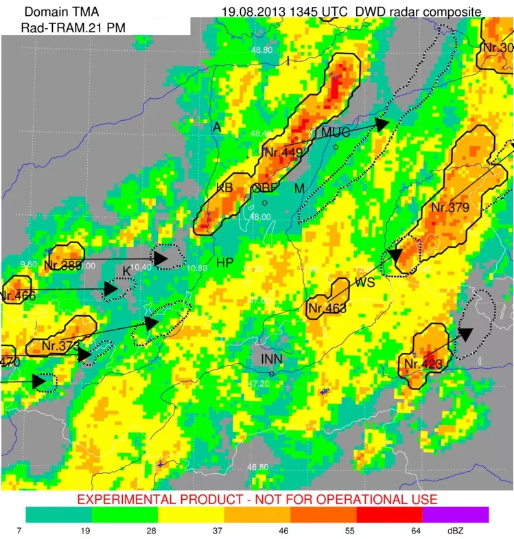
The main task of nowcasting is to identify the first signs of the development of hazardous phenomena on weather maps, and then track their movement. For this, data from a dense network of weather stations, as well as satellites, meteorological radars (SRL) and lightning direction finding systems are used. At present, Doppler SCRLs are widely used, which allow not only to observe the evolution of cloudiness, but also to instantly estimate the speed and direction of its movement (based on the Doppler effect), and quickly determine the zones of convective HH. Information is updated every 5-15 minutes, which is sufficient for the timely issuance of a storm warning.
The term “Nowcasting” (from the English – Nowcasting) was introduced into active use back in the 1980s in the MetOffice of Great Britain by K. Browning when describing the technology for extrapolating a sequence of radar images for predicting precipitation.